


 Download(50MB)
 2.0
2.0
 453.47KB
8.1
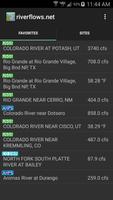
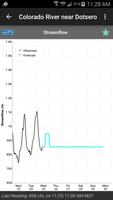
A tool for viewing real-time river level information.
RiverFlows offers a quick and easy way to view data from river gage sites using an Android device. This is useful for fishing, kayaking, rafting, canoeing, or any other pursuit that requires tracking lake and river levels in the U.S.
Supported Data Sources:
USGS
NOAA
US Army Corps of Engineers
Colorado Department of Water Resources
California Data Exchange Center
The RiverFlows app and widget are now open source!: https://github.com/robinmj/RiverFlows
 Similarity
January 21, 2026
January 21, 2026
January 20, 2026
January 20, 2026
January 20, 2026
January 20, 2026
January 19, 2026
January 19, 2026
January 19, 2026
January 18, 2026
January 18, 2026
January 18, 2026